
Page 22 - Respond 2022 Magazine
P. 22
Geospatial technology
trends for environmental
awareness
Environmental science is a Technology for conscious exploration of are important technologies for public and
multidisciplinary field that environmental resources private companies to have access to quality
integrates biological, social and In 2020, looking to understand climate information and to be able to reduce their
physical sciences to solve any change in the state of Tocantins, Brazil, environmental impact.
environmental problem that Codex started the project Climate Charts,
the world faces on a daily basis. creating a historical base of geospatial From the current global scenario, it
Scientists in the field examine data through data science resources. The is necessary to analyze how each
and research the interaction resulting database has a significant volume company can become aware and foster
between humans and the of information, as data was collected over understanding so that natural resources are
environment, analyzing the issues a 30 year period, which characterizes this a source of positive results, and not a target
that affect the planet - and each project as Big Data. for degradation and deforestation.
of them has a geographical
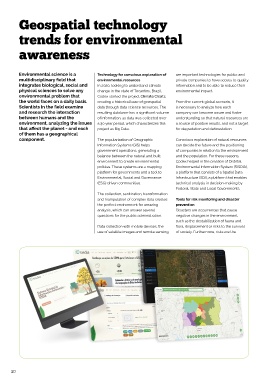
component. The popularization of Geographic Conscious exploration of natural resources
Information Systems (GIS) helps can decide the future and the positioning
government operations, generating a of companies in relation to the environment
balance between the natural and built and the population. For these reasons,
environment to create environmental Codex helped in the creation of Distrital
policies. These systems are a mapping Environmental Information System (SISDIA),
platform for governments and a tool to a platform that consists of a Spatial Data
Environmental, Social and Governance Infrastructure (SDI), a platform that enables
(ESG) driven communities. technical analysis in decision-making by
Federal, State and Local Governments.
The collection, sanitization, transformation
and manipulation of complex data creates Tools for risk monitoring and disaster
the perfect environment for amazing prevention
analysis, which can answer several Disasters are occurrences that cause
questions for the public administration. negative changes in the environment,
such as the destabilization of fauna and
Data collection with mobile devices, the flora, displacement or risks to the survival
use of satellite images and remote sensing, of society. Furthermore, risks are the
20